OHIO COAL GEOGRAPHY Today, I'd like to pass on a geography lesson I just learned. Let's start with a pop quiz:
1) Which of the Big Three Ohio cities (Columbus, Cleveland, Cincinnati) is closest to the majority of the state's working underground coal mines?
2) Which of the Big Three cities is closest to the seat of the state's biggest coal-producing county?
3) Which of the Big Three cities is the corporate headquarters of the company that mines over 40% of Ohio coal?
Okay, time's up. Put your pencils down and close your test booklets. The answers are:
Cleveland. Cleveland. And Cleveland.
Ohio's dominant coal-producing county is Belmont, on the Ohio River across from Wheeling. Its county seat, St. Clairsville, is 105 miles (as the crow flies) from downtown Cleveland. The distance to Columbus is 111 miles; to Cincinnati, 203 miles.
The state's two biggest underground mines, both in southern Belmont County, are the Powhatan No. 6 and the Century. Together they accounted for 10 million of the 23 million tons of coal mined in Ohio in 2004, the last reporting year. They also accounted for at least 40% of the state's 2,300 coal mining jobs. Both are owned by Murray Energy Corporation of Cleveland, whose sole shareholder is Robert E. Murray of Moreland Hills. (For more on Murray, see
this Columbus Dispatch article.)
As for the first quiz question, take a look at the map below. I've divided the state into four quadrants with the lines meeting at the intersection of Knox, Licking and Delaware Counties (near Centerburg, the state's acknowledged geographic center). The black circles are Ohio's eight working underground coal mines. The northernmost five are near Uhrichsville, Cadiz, and Salineville -- all in the northeast quadrant, and all closer to Cleveland than to Columbus. The Powhatan and Century mines, near Alledonia in southern Belmont County, are a few miles closer to Columbus... but they're about as far northeast as you can get and still claim to be in "southern Ohio".

If you did well on the quiz, you're a lot better informed than I was a week ago. Like many others who think of ourselves as "northeast Ohioans", I had "coal" and "southern Ohio" in a single mental box -- as in "the southern Ohio coal industry", or "coal miners in southern Ohio".
But a few days ago, looking around for stuff to read on mine safety and clean coal issues, I googled my way to
this page on the Ohio Department of Natural Resources website, with a link to the
2004 Report on Ohio Mineral Industries, along with
this interactive map of mining operations.
So now I know better. I've learned that the state's coal industry is concentrated in what you might call "Mideast Ohio", starting at the southern edge of
Northeast Ohio (Stark and Columbiana Counties), and running south along the first fifty miles of the Ohio River border (East Liverpool, Steubenville, Martin's Ferry) and counties just to the west. While this area is routinely included in maps of
"Appalachian Ohio", its center of gravity isn't Athens or Portsmouth, but Wheeling and Pittsburgh.
I'm not sure what to make of this information, except that it would be a good idea to stop thinking about Ohio politics as a North/South proposition.
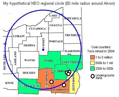
But here's one more interesting map exercise: In Cleveland, we're in the habit of defining the NEO region as a group of counties radiating outward from... well,
us. Suppose we instead define the region by drawing a circle around a more central point, like, say, downtown Akron. Let's make the radius fifty miles -- an hour's drive -- which would take in Youngstown on the east, Painesville and Vermilion on the lakeshore, and Ashland to the southwest.

Inside that fifty mile radius, to the south and southeast, would be
half of Ohio's eight underground coal mines, and more than 10% of the state's total coal production.
Does that make coal part of the NEO regional economy? If not, why not?